Creating a CSV file for collaborative georeferencing
Minimum Required Fields:
- CatalogNumber (must be unique)
- ScientificName
- Country
- StateProvince
- County
- Locality
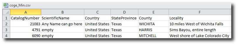
Link to minimal csv file shown above
The recommended approach would be to create a minimal file for each dataset you wish to upload, as many of the optional fields are ignored by the georeferencing process.
Optional Fields:
- FieldNumber*
- YearCollected*
- MonthCollected*
- DayCollected*
- DateLastModified
- BasisOfRecord
- InstitutionCode
- CollectionCode
- Kingdom
- Phylum
- Class
- Order
- Family
- Genus
- Species
- Subspecies
- ScientificNameAuthor
- IdentifiedBy
- YearIdentified
- MonthIdentified
- DayIdentified
- TypeStatus
- CollectorNumber
- Collector
- JulianDay
- TimeOfDay
- ContinentOcean
- Longitude
- Latitude
- CoordinatePrecision
- BoundingBox
- MinimumElevation
- MaximumElevation
- MinimumDepth
- MaximumDepth
- Sex
- PreparationType
- IndividualCount
- PreviousCatalogNumber
- RelationshipType
- RelatedCatalogItem
- Notes
Fields marked with an * may be displayed in Client UI along with required fields