 Overview
The GEOLocate project is an effort to develop software and services for translating textual locality descriptions associated with biodiversity collections data into geographic coordinates. The following are an actual sample of data georeferenced by GEOLocate:
- Arkansas River at River Mile 10 boat landing., USA, Arkansas, Desha
- Green River at Roachville ford approximately 2 mi. E. of Greensburg, USA, Kentucky, Green
- Alabama River at Wilcox Bar; River Mile 120., USA, Alabama, Wilcox
- Missouri River 3 mi. SE of Pierre, South Dakota., USA, South Dakota, Hughes
- Natalbany River at U.S. Hwy. 190, USA , Louisiana, Tangipahoa
- Tussahaw Creek at LeGuin Mill Road, approximately 3.5 mi. ENE Locust Grove - Segment 3., USA, Georgia, Henry
- Escatawpa River at Hwy. 612., USA, Mississippi, George
- South Fork Little Red River at Arkansas Hwy. 95, SW Clinton, Section 11., USA, Arkansas, Van Buren
- Little Pine Barren Creek at Hwy. 99; T4N R32W Sec. 4., USA, Florida, Escambia
- t1N r3e sec. 13, USA, Nebraska, Jefferson
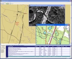
The algorithm used by GEOLocate begins by standardizing the locality string into common terms and parsing out distances, compass directions, and key geographic identifiers. This information is then used in a series of lookups and displacement calculations to determine geographic coordinates. Placename, river mile, legal land description and higway-waterbody crossing datasets are used for lookups. Displacements from these lookups are calculated if indicated by the parsed locality information. Coordinates output from the initial georeferencing may be further refined via an additional function to scan the locality string for waterbody names and “snap” output coordinates to the nearest point on the waterbody found. This feature has proven very useful for aquatic collections. The resulting coordinates are then ranked based on the type of information found within the string and plotted on the digital map display for user verification, correction and error determination.
 In addition to the automated
processing of locality description, One of our goals of was to provide an interface by which users could georeference
records one by one or in batches from files, vizualize and correct calculated
coordinates and determine polygonal error descriptions.
The standalone desktop version of GEOLocate uses XML as
its native file format but also supports data import from .CSV and delimited
.TXT files. Once coordinates have been derived from a locality description
adjustments may be made by simply click and dragging a displayed point on a map.
Error estimates can then be recorded as the maximum extent which a description
could occupy. This extent is represented as a comma delimited array of
polygon vertices and can easily be drawn onto the map.
You can try out an
online version of the process or
download a free copy of the full featured standalone version.
Developers are also invited to make use of our
georeferencing web services into their own applications
and/or databases. A lightweight client application based
on these services is currently under developement.
In addition to the automated
processing of locality description, One of our goals of was to provide an interface by which users could georeference
records one by one or in batches from files, vizualize and correct calculated
coordinates and determine polygonal error descriptions.
The standalone desktop version of GEOLocate uses XML as
its native file format but also supports data import from .CSV and delimited
.TXT files. Once coordinates have been derived from a locality description
adjustments may be made by simply click and dragging a displayed point on a map.
Error estimates can then be recorded as the maximum extent which a description
could occupy. This extent is represented as a comma delimited array of
polygon vertices and can easily be drawn onto the map.
You can try out an
online version of the process or
download a free copy of the full featured standalone version.
Developers are also invited to make use of our
georeferencing web services into their own applications
and/or databases. A lightweight client application based
on these services is currently under developement.
Web Applications
Georeference collections data using your web browser. Quick and easy georeferencing.
Web Services
Integrate georeferencing into your own databases and applications using GEOLocate webservices.
Collaborative Georeferencing
Build communities, share data, relate records across collections and improve verification efficiency.