 Collaborative Georeferencing
 The goal of this project is to provide a mechanism
whereby groups of users can form communities to
collaboratively georeference and verify a shared dataset.
This collaborative georeferencing framework consists of
two end-user components:
The goal of this project is to provide a mechanism
whereby groups of users can form communities to
collaboratively georeference and verify a shared dataset.
This collaborative georeferencing framework consists of
two end-user components:
- The GEOLocate web-based collaborative client for reviewing and editing community records.
- Web-based data management portal for creating and managing communities, their respective users and data sources
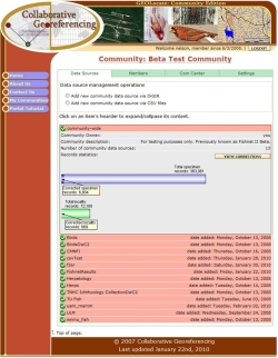 Shared community datasets created via the portal may
consist of multiple underlying data sources from either
live DiGIR providers and/or uploaded text files. Support
for TAPIR providers is currently under development. Data
are stored using the full Darwin Core 1.2 specification,
but subsets and/or alternatives schemas may be imported
using the schema mapping interface. During import, data
items are automatically normalized, georeferenced and
related to one another via a similarity index. This index
is used to identify all records that appear to describe
the same collection locality regardless of syntax. During
coordinate verification, users have the option to
re-classify records that were incorrectly related to one
another.
Shared community datasets created via the portal may
consist of multiple underlying data sources from either
live DiGIR providers and/or uploaded text files. Support
for TAPIR providers is currently under development. Data
are stored using the full Darwin Core 1.2 specification,
but subsets and/or alternatives schemas may be imported
using the schema mapping interface. During import, data
items are automatically normalized, georeferenced and
related to one another via a similarity index. This index
is used to identify all records that appear to describe
the same collection locality regardless of syntax. During
coordinate verification, users have the option to
re-classify records that were incorrectly related to one
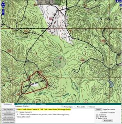
another. Verification and correction of the computer generated geographic coordinates is accomplished using the GEOLocate desktop application. GEOLocate allows users to login to their communities, retrieve and visualize results, make any necessary corrections, provide additional comments, define errors as polygons, and save the results back to the shared dataset. The verified results of georeferencing can then be downloaded via the portal’s data management interface for re-import to the parent database.
To examine the gains in efficiency over traditional georeferencing 2100 randomly selected collecting events from the TUMNH fish collection were imported and georeferenced using the collaborative georeferencing framework. The TUMNH fish collection was georeferenced by hand in the mid to late 90’s and therefore provides a useful test bed for assessing the efficiency and accuracy of automated methodologies. Of the 2100 records, 30% were identified as being similar to other records and an additional 33% were duplicates leaving a total of 782 unique locations requiring correction, a 63% reduction in effort overall.
Video Tutorials
- Using the Collaborative Georeferencing Web Client:
Web Applications
Georeference collections data using your web browser. Quick and easy georeferencing.
Web Services
Integrate georeferencing into your own databases and applications using GEOLocate webservices.
Collaborative Georeferencing
Build communities, share data, relate records across collections and improve verification efficiency.